Explore Geotourism Locations
Currently Viewing
National Geographic Map Locations (189)
-
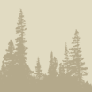 Covered Bridges of South Douglas County
An estimated 450 covered bridges were built in Oregon between 1905 and 1925. By 1977 that number had dwindled to 56. Today there are only 50 covered bridges in Oregon that were designed or built for vehicular traffic. While most of Oregon’s remaining covered bridges…
Location: 207 N.W. Pleasant St., Myrtle Creek, OR 97457 -
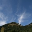
Crater Lake
Crater Lake is a treasure worth preserving. Formed 7,700 years ago when Mt. Mazama erupted, the caldera that makes up Crater Lake took up to 800 years to fill up, and it’s the deepest in North America at 1,932 feet. The road to the North entrance…
Location: North Umpqua Highway 138, Crater lake, OR 97604 -
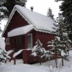 Crescent Creek Cottages
Crescent Creek Cottages was built in the 1910s by the workers building the railroad. Crescent Lake was a stop on the railroad, and a town was born. The cottages have been maintained for almost 100 years. Railroad employees still come to stay at the cottages…
Location: 19100 Highway 58, Crescent Lake, OR 97425 -
Crown Point – Columbia River Gorge National Scenic Area
Crown Point provides an incredible eastward view of the Columbia River Gorge National Scenic Area. On the site is Vista House, a beautiful, historic stone structure and visitor center. During fair weather, the views west, north and especially east into the heart of the Columbia Gorge…
Location: 40700 E Historic Columbia River Hwy, Corbett, OR 97019 -
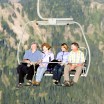
 Crystal Mountain
Crystal Mountain Resort is predominantly a ski area but this natural land has much to offer in the off-season months as well. In the summer the resort provides scenic chairlift rides, a mountaintop restaurant, hiking, fishing, tennis, and mountain biking. After Labor Day the ski…
-
 Crystal Mountain Summit House
Hop on the Rainier Express chairlift or take a challenging hike, to Washington State’s highest restaurant (6,872 feet) where you can have your butternut squash ravioli with a complimentary view of the gorgeous Cascades. On a clear day, you can see many of the area’s…
Location: 33914 Crystal Mountain Blvd., Crystal Mountain, WA 98022 -
Dee Creek Farm
Specialty cheeses, poultry, vegetables, and more, produced on this dynamic, chemical free farm. Dee Creek currently have a creamery, mobile processing unit, certified kitchen, movable animal houses, greenhouses, ponds, an old barn, and a farmhouse from the 1900’s. In an effort to serve the community more…
Location: 2402 Little Kalama River Road, Woodland, WA 98674 -
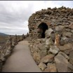 Dee Wright Observatory
The Dee Wright Observatory has gorgeous views of many volcanoes of the Oregon Cascades, and is situated in the center of a lava field as an ideal location for viewing various cinder cones, volcanoes and other points of interest. Viewpoints from inside the observatory include…
Location: Summit of McKenzie Pass, State Route 242, OR 97759 -
Deschutes National Wild and Scenic River
The Lower Deschutes River stretches 100 miles, from the Warm Springs Indian Reservation to the Columbia River. Winding its way through Oregon’s high desert, the Deschutes River is known for its whitewater rafting, world-class fishing, unique geology and wildlife viewing. On any given day you…
Location: Maupin, OR 97037 -
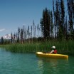 Deschutes Paddle Trail
Whether you want to sea-kayak the beautiful High Cascade Lakes with sweeping mountain views, paddle a gentle section of the Lower Deschutes River among the otters, beavers and eagles, or whitewater-raft an exciting stretch of river just minutes from Downtown Bend, the Deschutes Paddle Trail…
Location: Bend, OR
 Central Cascades Geotourism Map