Explore Geotourism Locations
Currently Viewing
All Geotourism Locations (450)
-
 City of Dufur
Dufur is a small, rural agricultural community that’s striving to preserve its local history through buildings, museums and festivals. Dufur’s location is close enough to metropolitan populations (2 hours from Portland) to allow “city dwellers” the opportunity to experience some of what rural Oregon has…
Location: 040 Main Street, Dufur, OR 97021 -
 City of Rogue River
Local communities in Southern Oregon are building the Rogue River Recreational Corridor and Greenway. It’s best described as an emerald necklace of parks and public-access areas along the Rogue River connected by a ribbon of greenway trail spanning 30 miles from Grants Pass to Central Point. …
Location: Depot Street Bridge, Rogue River, OR 97537 -
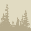
Clackamas River Corridor
Welcome to the wilderness. This corridor from Estacada to Ripplebrook Ranger Station and on to Detroit Lake and the Santiam Pass offers a glimpse into glorious forested habitat, havens for deer, elk, bear, critters and birds. Breathtaking geologic basalt outcroppings, rushing whitewater and the glassy-still…
-
Clackamas River Trail
Forty miles from busy downtown Portland, the Clackamas River Ranger District maintains the 8.2-mile Clackamas River Trail. It’s an escape from everyday life, and offers the perfect getaway for hiking, running and even snowshoeing. The trail passes waterfalls, old-growth forests, a partial cave and beautiful…
Location: Highway 224, Indian Henry Comaprground, Estacada, OR 97023 -
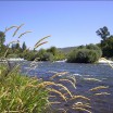
 Clear Lake
Clear Lake, the source of the famous McKenzie River, was formed more than 3,000 years ago when volcanic lava flow blocked a stream bed. The spring-fed lake is exceptionally clear, with visibility to the bottom more than 100 feet down in some spots – with…
Location: Clear Lake Resort -
Climb Mount St. Helens
Beginners and experienced climbers alike can summit the 8,365-foot active volcano for spectacular views of the caldera and mountains beyond. Though strenuous, the climb is not technical and usually takes 7 to 12 hours round-trip. Mount St. Helens offers a wonderful opportunity to combine recreation…
Location: Climber's Bivouac, Cougar, , WA 98616 -
Cloud Cap Inn
The Cloud Cap Inn (or Chalet) is a special building located in a very beautiful place, at the 6,000 foot level of the north side of Mt. Hood. It is also an old and historic place, built in 1889, that represents a time in the…
Location: Mt. Hood National Forest, Parkdale, OR 97041 -
Coldwater Lake
Located at milepost 45 on State Route 504, Coldwater Lake Recreation Area offers a unique opportunity to explore the lake’s origins and current flora and fauna. Enjoy a leisurely stroll on a quarter mile interpretive boardwalk that describes how the events of the 1980 eruption…
Location: Mile Marker 43, Mt. St. Helens, WA 98649 -
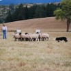 Colliding Rivers Classic Sheepdog Championships
The event is unique in its heritage theme of sheepdog herding, and is held at a working ranch located in at a historically significant area of Douglas County, near the county seat of Roseburg. The event is named after a distinct nearby geological location, the…
Location: 10879 Buckhorn Road, Glide, OR 97443 -
Colliding Rivers Viewpoint
This confluence is a rare phenomenon: two rivers, the North Umpqua and Little River, meet head-on. This site was once an important fishing village for the Umpqua Indians, and the area is rich in their culture. The North Umpqua Ranger District cares for the site,…
Location: 16 Miles East of Roseburg, OR
 Central Cascades Geotourism Map